Mapping practices are evolving beyond orientation and representation toward futures built in dialogue with communities: blending oral histories, sensor networks, ancestral memory, and speculative modelling. Across a range of collaborative projects—from sea level rise workshops to mental health geographies—designers and artists are forging speculative cartographies that insist on community authorship of spatial futures.
Sea‑Level Rise as Participatory Story‑Map
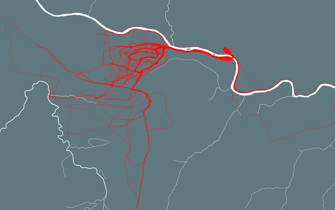
Stamen Design is a data visualization and cartography studio based in San Francisco, renowned for translating climate data into spatial tools and public-facing experiences. For example, their Surging Seas collaboration with Climate Central created interactive sea‑level rise visualizations aimed at helping people understand risk at the neighborhood level by overlaying inundation projections with familiar local cityscapes. While Stamen offers public and custom workshops on spatial data and visualization—such as hands‑on “Working & Designing with Spatial Data” classes in JavaScript and cartography tools—they do not publicly document specific community workshops that combine flood projection maps with community video‑recorded testimonies.

In parallel, the work of speculative cartographer Jeffrey Linn, featured by Stamen, repurposes vintage gas‑station maps as backdrops for superimposed sea‑level rise overlays. His maps, part of the Petrofuture series and his broader Conspiracy of Cartographers archive, visualize how global coastal cities might reconfigure under extreme melt—turning conventional climate visualizations into tactile speculative scenarios.
Eve Mosher’s landmark public‑art intervention HighWaterLine similarly harnessed community engagement as data generation. Walking hundreds of miles along shorelines in New York and Miami, she chalked predicted flood heights in public space, inviting passers‑by to engage directly with climate projections and share stories. The eventual validation of her projections during Hurricane Sandy underscores the power of community‑situated mapping to anticipate future change and catalyze preparedness.

Ancestral Waterways and Riverhood Frameworks
Beyond sea‑level futures, speculative mapping also draws on ancestral river ecologies. Research initiatives like RIVERHOOD: Living Rivers and New Water Justice Movements, an ongoing 5‑year research initiative led by Wageningen University & Research, investigate new water justice movements across global cases in Ecuador, Colombia, Spain, and the Netherlands. These movements rethink rivers as living socio‑ecological agents and develop frameworks around water justice, nature‑rights, and hydrosocial territories. While primarily academic in orientation, Riverhood introduces conceptual tools such as “river‑as‑ecosociety,” “river‑as‑territory,” “river‑as‑subject,” and “river‑as‑movement.”
The project explores how Indigenous guardians, grassroots organizations, and water justice coalitions conceptualize and enact ancestral river ontologies—offering a theoretical foundation for participatory studios that might map ancestral flow‑paths, historic river networks, and multi‑species territories in collaboration with communities and oral‑memory holders.
A notable practice in this vein is Kartta Labs, an open‑source, time‑travel mapping tool that reconstructs historical cityscapes from archival maps and crowdsourced data. Though focused on urban form, the infrastructure supports layering oral histories and sensory memory data to destabilize fixed timelines—inviting communities to trace ancestral ecologies and projected environmental futures within a unified interface.

Mental‑Health and Migratory Geographies
Community mapping also extends into psychosocial terrain. In Canada, designer Lucas LaRochelle’s Queering the Map platform launched in 2017 as a community‑created atlas of queer experiences. Users drop pins and submit personal memories tied to specific locations—mapping emotional geographies and migratory affect. By 2025, the platform has gathered over half a million submissions in 23 languages, offering a powerful archive of place‑based emotional history that frames queer temporal futurity rooted in spatial belonging and movement.

More broadly, artists working across migration and mental‑health mapping draw on natural‑landscape metaphors to render pathways of displacement, resilience, and belonging. Emerging scholarship references eco‑social perspectives where nature imagery becomes a vessel for integrated, spatially anchored narratives of migration and healing. Speculative cartographers are incorporating these ideas into community workshops where participants trace mental‑health trajectories across geographies of origin, transit, and settlement—rendering emotional transitions visible through interactive visual forms.
Common Threads: Tools, Ethics, and Community Agency
Across these projects, several common threads emerge that highlight the evolving role of mapping as both a design practice and a community tool. Many initiatives employ hybrid data layers, weaving together climate projections, sensor readings, oral histories, and personal narratives to build multidimensional understandings of place. Eve Mosher’s HighWaterLine, for example, combined scientific flood data with community testimony as she marked potential inundation zones directly onto city streets, making climate futures visible and personally resonant. This emphasis on community co‑design is equally evident in Lucas LaRochelle’s Queering the Map, where users themselves contribute memories and experiences, effectively authoring a collective cartography of queer life. Such projects also embrace material experimentation: from Mosher’s chalk interventions in public space to the digital interfaces of Queering the Map or Stamen Design’s story‑mapping workshops.

A commitment to temporal layering further distinguishes these works, merging past, present, and projected futures—whether through ancestral river tracing frameworks like Riverhoodor LaRochelle’s mapping of affective histories and imagined queer futures. Underpinning all of these practices is a strong focus on ethical design, ensuring transparency around data sources, honoring the context of shared narratives, and safeguarding community stewardship of the outcomes.
Institutional Networks and Future Mapping Futures
Organizations like the Livingmaps Network convene conferences, workshops, and exhibitions that foreground participatory and speculative mapping. Their 2025 program on More‑than‑human Mappings included sessions led by practitioners such as Kimbal Bumstead and Sana Murrani, whose project The Ruptured Yazidi Atlas explored trauma, Indigenous sensory geographies, and ecological justice through embodied mapping practices. While the specific focus of each event shifts with its invited contributors, the network consistently frames maps as co‑constructed interfaces rather than static artifacts—an approach that resonates strongly with future‑conscious creative audiences.

Why It Matters for Creative Futures
For designers and artists working at the intersection of creativity and foresight, speculative cartography provides a critical toolkit. It grants communities narrative agency, shifting the act of mapping from something done to them to something authored by them. It fosters future literacies, enabling participants to visualize and anticipate projected landscapes in ways that shape collective imagination. At the same time, these practices advance design justice, grounding projects in consent, cultural context, and equitable representation. Their strength lies in cross‑disciplinary fluency, integrating GIS technologies, oral histories, sensor data, storytelling, and participatory design methods into layered, community‑driven maps. In this way, speculative cartography functions not merely as representation but as a strategy for engaging communities in shaping spatial futures—whether charting climate resilience, mapping memory, tracing migration, or visualizing mental health geographies.


